Nutrient over-enrichment in estuaries and coasts due to human activity…
Nutrient modelling indicates most nutrient losses to surface waters are from diffuse sources
New estimates indicate that diffuse sources outweigh point sources in most sub-catchments. The main cause of unsatisfactory water quality in Ireland is excess phosphorus and nitrogen emissions that can come from sewage discharges, agricultural land, and other sources. Recent EPA-funded research, the CatchmentTools project, has produced estimates of the nutrient losses to Irish surface waters from nine main sources using geospatial modelling. The sources were grouped into point discharges (municipal wastewater treatment plants, industry and septic tank systems) and non-point, or diffuse, sources (pasture, arable, diffuse urban, forests, peatlands, and deposition on water). The results were used by the EPA Catchments Unit to support the identification of significant pressures for the development of the River Basin Management Plan.
Main sources of phosphorus and nitrogen in Irish rivers These new estimates indicate that over 50% of phosphorus and over 80% of nitrogen losses to surface water are from ‘non-point’ sources.
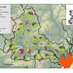
The main sources of phosphorus are municipal wastewater discharges and agriculture, with the relative contributions varying by region (Figure 1). The clear dominance of wastewater in the East (78%) reflects the distribution of the population, which is clustered around Dublin. Pasture is the main diffuse source of phosphorus, contributing up to 47% at regional level. In these estimates, however, runoff from farmyards are included in the ‘diffuse’ pasture category even though they are point sources. Forests and peatlands were estimated to contribute up to 13% and 23%, respectively, of phosphorus emissions in some regions, whereas contributions from septic tank systems and regulated discharges (i.e. industrial discharges) were low across all regions, representing less than 3% of phosphorus emissions.
Agriculture is the main source of nitrogen in Irish rivers, which is typically the case across Europe (Bøgestrand et al., 2005). Contributions from wastewater were low in all regions (less than 7%) except for the East (33%), the latter due to the high proportion of the population living in this region (Figure 1).
Further details on the methods, assumptions and testing of the Source Load Apportionment Model (SLAM) that was developed to produce these results are in Mockler et al. (2017).
Diffuse sources outweigh point sources in over 90% of sub-catchments
Point sources are generally located in urban areas where the associated wastewater and industrial discharges drive high levels of emission. In fact, looking at a local scale, when we examine the 583 subcatchments across Ireland, only 8% of these are dominated by point sources and these typically impact estuaries and coastal waters of towns and cities (Figure 2). In the remaining areas, a high percentage of phosphorus and nitrogen emissions to water are from pasture. This reflects the fact that farmland covers ~65% of the land surface of Ireland. For phosphorus, these areas typically coincide with agricultural lands with poorly draining soils. For nitrogen, however, agricultural intensity has a dominant impact, with most emissions coming from the East and South of the country reflecting the coincidence of higher intensity agricultural land on more freely draining soils.
Although 30% of population use septic tank systems, these contribute less than 3% of total annual nitrogen and phosphorus loads. However, the treatment efficiency from septic tank systems varies widely and underperforming systems have the potential to cause impact in small streams, particularly in areas of poorly draining soils and subsoils during low flow periods, when there is little baseflow for dilution (Archbold et al., 2010; Withers et al., 2012). In areas with a high density of septic tank systems (over 19 per km2), their contributions to annual nutrient loads can be up to 22% for phosphorus and 13% for nitrogen (Gill and Mockler, 2016).
Supporting Catchment Characterisation
Catchment management can be supported by modelling at a range of scales and levels, all of which can reduce the resources required to analyse substantial amounts of information.
The Source Load Apportionment Model results were one of the many datasets included in the EPA’s Water Framework Directive characterisation process for the second cycle of the Directive, that informed the assessment of nutrient load information in a logical, structured, consistent and comparative way across the country and has therefore enabled robust and practical use of the information. Where chemical and ecological monitoring data, local knowledge or other information indicated that excess nutrients were impacting on a water body, the model results were interpreted by catchment scientists along with the other national datasets including:
• ecological status and trends in ecological and chemical monitoring data;
• information on land use, pressures, pathways and the sensitivity of receptors;
• licence, enforcement, audit and inspection information from regulatory agencies; and
• local, on-the-ground knowledge from the Local Authorities and Fisheries agency staff.
Reducing nutrient losses and improving water quality – understanding pressures and connections
Agriculture has been identified as a significant pressure in 729 (64%) river and lake water bodies that are At Risk of not meeting their environmental objective (draft RBMP). Progress has been made in reducing nutrient losses from agriculture in recent decades, but further improvements are needed to decouple the relationship between agricultural productivity and emissions to water. Studies have shown that nutrient losses from agricultural land do not occur uniformly in the landscape but from ‘hot spots’, or critical source areas, where the source of nutrients have a pathway that connects them to a surface water body. For phosphorus, this pathway can be poorly drained slopes, whereas for nitrogen well drained soils over a permeable aquifer is a major pathway (Deakin et al., 2016). The results from the CatchmentTools project were used to examine the dominant pathways in all sub-catchments, and showed that rate of phosphorus losses from pasture increases with the percentage area of poorly drained soils in a sub-catchment. These results were statistically significant – r2 = 0.87, p = <0.001, see Figure 3.
New Irish research is developing water quality models and risk assessment tools to help identify these high-risk areas to help reduce the overall losses of nutrients to surface waters in Ireland. Discover more research from the DiffuseTools project at cwrr.ucd.ie/diffuse
Eva Mockler, UCD Civil Engineering A fully referenced version of this article will be available on www.catchments.ie


