Rivers trusts are charities, established by local people to look…
Dublin Bay – A UNESCO Biosphere
On June 24th 2015, the designation of Dublin Bay Biosphere was announced. Biospheres are internationally recognised for their biological diversity yet also actively manage to promote a balanced relationship between people and nature. The designation is awarded by the United Nations Educational, Scientific and Cultural Organisation (UNESCO) but managed in partnership by communities, NGOs and local and national governments. There is a global network of 651 Biospheres in 120 countries.
The Dublin City branch of Comhairle na nÓg made a video in Summer 2016 explaining about Dublin Bay Biosphere in their own words:
In 1981, UNESCO designated North Bull Island as a Biosphere because of its rare and internationally important habitats and species of wildlife. There have subsequently been additional international and national designations, covering much of Dublin Bay, to ensure the protection of its water quality and biodiversity. To support sustainable development, UNESCO’s concept of a Biosphere has evolved to include not just areas of ecological value but also the areas around them and the communities that live and work within them. To fulfil these broader management aims for the ecosystem, the Biosphere has now been expanded to cover Dublin Bay, reflecting its significant environmental, economic, cultural and tourism importance, and extends to over 300 km2. Over 300,000 people live within this area.
All Biospheres have three main goals:
- Conservation: promoting the conservation of landscapes, habitats, wildlife and cultural values
- Learning: supporting education and research, for a better understanding of nature and global issues
- Development: fostering a sustainable economy and society for people living and working in the area
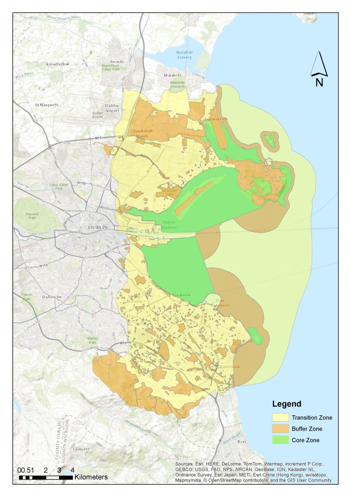
Dublin Bay Biosphere contains three different management zones.
The core zone comprises protected areas which are managed for the conservation of landscapes and biodiversity. It includes Baldoyle Bay, Ireland’s Eye, Howth Head, North Bull Island, the Tolka Estuary and Dalkey Island and covers 50 km2.
The surrounding or adjoining buffer zone is managed to support the core zone and research, monitoring, training, education and other environmentally sustainable activities are encouraged here. It comprises 82 km2 of public and private green spaces such as parks, greenbelts and golf courses.
The transition zone is the outer zone, where sustainable social and economic development is strongly promoted. It covers 173 km2 and includes residential communities, harbours, ports and industrial and commercial areas.
Dublin Bay is subject to an existing comprehensive legislative and policy planning framework implemented by all levels of government. The Biosphere designation brings no new regulations; its aims are achieved by people working together. The Biosphere is managed by the Dublin Bay Biosphere Partnership, which includes Dublin City Council, Dublin Port Company, Dún Laoghaire-Rathdown County Council, Fingal County Council and the National Parks & Wildlife Service of the Department of Arts, Heritage and the Gaeltacht. This partnership works with community groups, NGOs, local businesses and schools. A Conservation Programme, a Business Development Plan for sustainable tourism and recreation and a Research and Education Strategy, including a programme of events, will be developed for Dublin Bay Biosphere.
Learn more:
For further information, please visit our website www.dublinbaybiosphere.ie or follow us on Facebook or Twitter.
www.facebook.com/dublinbaybiosphere
www.twitter.com/dublinbiosphere
Article by Jenni Roche, Coordinator, Dublin Bay Biosphere.


